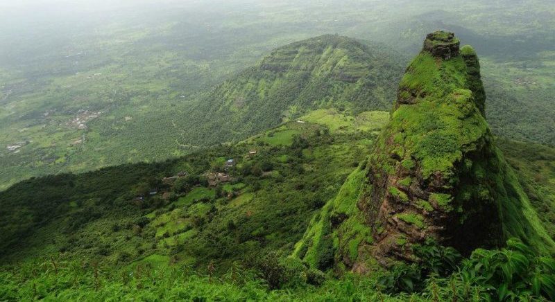
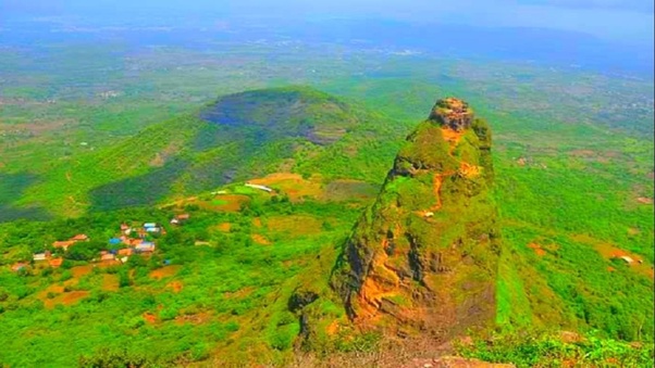
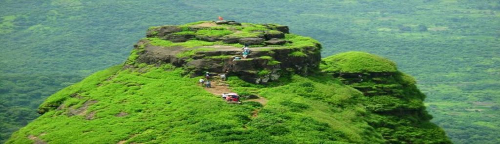
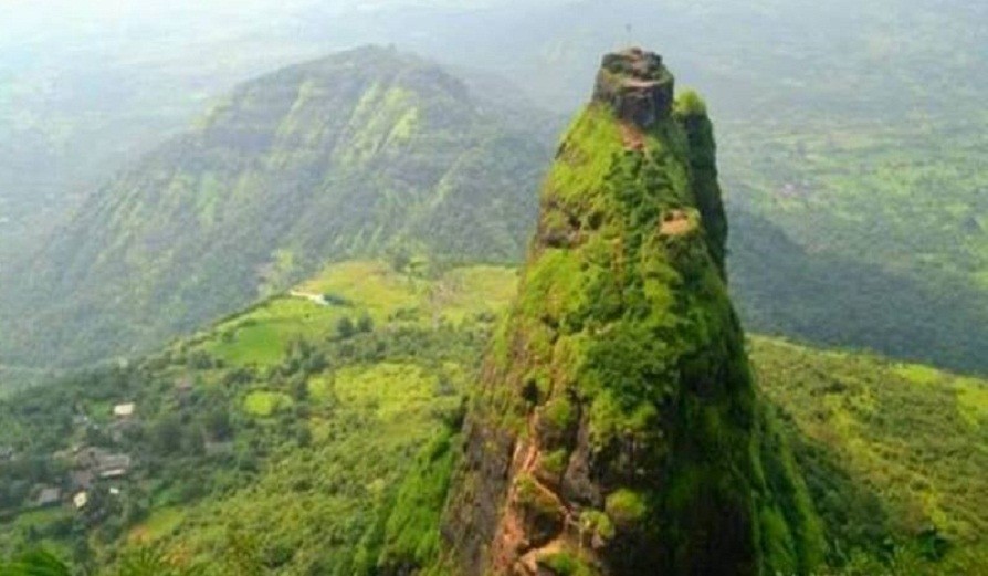
In the Western Ghats near Mumbai, at a hefty altitude of 701 metres (2,300 feet) above sea level lies the world’s most dangerous fortress: Kalavantin Durg, which (according to legend) was constructed in honour of a Queen Kalavantin. Offering gorgeous views and abundant beauty – via rugged terrain with narrow rock-cut steps, steep slopes and no support whatsoever – the trek to and from the fortress is dangerous yet thrilling. Kalavantin Fort is famed as the ‘Climb to Heaven’, owing to its dangerous nature and the bird’s eye view of the immense beauty that await atop.
Location: Prabalgad (also known as Muranjan, Pradhangad or Prabalmachi) is located between Matheran and Panvel and comes under the Raigad District in the state of Maharashtra, India. The Prabalgad Fort stands at an elevation of 2,300 feet i.e. 700 meters in the Western Ghats. The fort was previously known as Muranjan until it was taken over and renamed by the Maratha forces under Chhatrapati Shivaji Maharaj’s rule. Its sister fort is Irshalgad. Right next to Prabalgad, to its north, lies the steep Kalavantin fort.
Geography: Prabalgad lies on the prabal plateau between Matheran and Panvel and can be easily spotted from the Mumbai-Pune expressway. The “Ulahas River” runs to the east of the fort while the “Gadhi River” runs to the west. The Patalganga River is to the south. The forts of Chanderi and Peb are to the west. The Manikgad Fort is to the south while the Karnala fort is located towards the north.
Kalavantin (also known as Kalavati or Kalavantinicha Sulka) is a high pinnacle on the northern edge of the Prabal plateau. It is located near the Machi and near the Vajepur village. This is the site of the Kalavantin Durg.
History: The Prabalgad Fort was built by the Bahmani Sultanate to keep an eye on the Panvel Fort and the Kalyan Fort in the North Konkan area. Around 1458 A.D, “Malik Ahmad” the prime minister of the kingdom of Ahmednagar, took over the fort during his conquest of Konkan. After disintegration of the Bahmani Sultanate, the fort remained with the Ahmadnagar Sultanate.
During the collapse of the Ahmadnagar Sultanate, Shahaji led a helping hand against the separate forces of the Mughal Empire and the Adil Shahi dynasty. After the collapse of the Sultanate, he moved to Muranjan along with his wife Jijabai and son Shivaji for a brief period of time.
However, following Shahaji’s defeat and the agreement of Mahuli, North Konkan along with the fort, was ceded to Mughals who granted ruling authority of the area to Adilshah of Bijapur. Chhatrapati Shivaji conquered the fort from the Mughals in 1657 A.D, after which he established himself in the Kalyan-Bhivandi area.
During the attack by Chhatrapati Shivaji, the fort was governed by “Kesar Singh”, a Mughal sardar, and was the only fort to put up a strong resistance. Singh died during the battle in October 1657. Kesar Singh’s mother hid herself and her grandchild during the attack. Chhatrapati Shivaji, in an act of kindness made sure the lady and the child were allowed a safe passage out.
In the year 1826, Umaji Naik, a freedom fighter and his associates were believed to have made the fort as their home for a brief period of time.
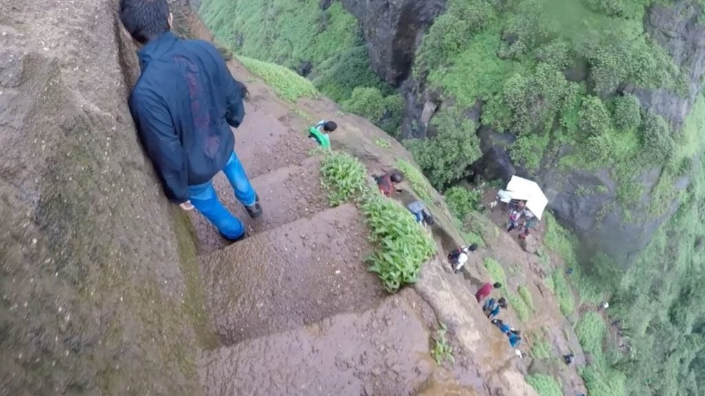
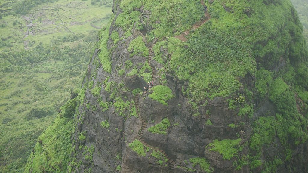
Trek to Kalavantin Durg: From the base point (in the village of Thakurwadi) to Kalavantin Durg and the Prabalgad Fort, the trek to this adrenaline-sparking fortress take about a little over three hours and is accessible by zigzag stairs carved into the edges of the rocky mountains, with swathes of scree and no guard rails or ropes. The trail gets notably steeper and vertigo-inducing on the way up – though this doesn’t deter those in pursuit of heart-pounding adventure – but jaw-dropping views and beautiful scenery on the way up make the trek all the more worthwhile. Expect to catch a glimpse of the tiny waterfalls south of Kalavantin Durg.
Medical Advise: Anyone suffering from vertigo should avoid doing this trek.
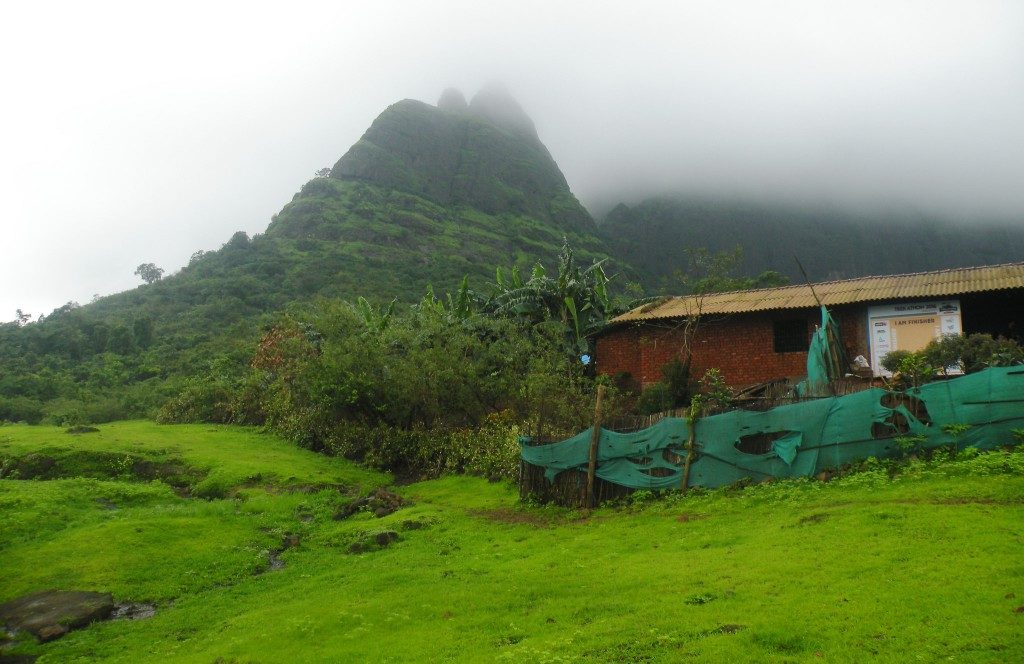
The trek is punctuated with tea and snack stalls, followed by breakfast point that is nestled at the lower plateau of Prabalmachi, the midway hamlet base nestled at an elevation of 390 metres (1279.5 feet) above sea level. This is the point to relax, fill up for the way forward, top up water bottles, and take some Instagram-worthy photos (stunning views of lush green slopes, unexploited nature and the valley below can be seen from this point).
From this point forward, it’s quite a precipitous path, and any rainfalls gives it a whole new level of risk as the path gets slippery, thus requiring the trekkers to cling on to the rocks and roots of trees lining the way. At some points, the path demands scrambling up the steep slopes and over the rocks.
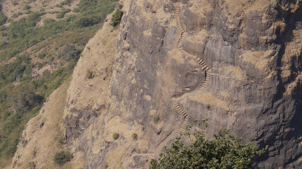
Activities: At this altitude, cling to the rocks for a reasonable grip when it gets windy. Higher and higher – complete with undulating terrain, rocky patches and waterfalls gushing down the steps – the trail gets even more treacherous until climbers finally reach the pinnacle of the Kalavantin Durg, witness the bird’s eye view and forget all about the arduous ascent. Soak in the gorgeous views of the Western Ghats, Prabalgad, Peb, Irshalgad and Chanderi Forts as well as panoramic vistas of Matheran and the city of Mumbai.
Stay: Prabalmachi Village offers numerous homestay options, or a tour operator would arrange accommodation for climbers
The main challenge of the Kalavantin Durg trek is the path back down, filled with boulders and slippery terrain. While descending, follow the narrow trail leading to Prabalgad Fort, another must-see spot, which takes just over an hour or so to reach. The gradient is tricky, steep and rocky, so it is advisable to have a professional trekker along. While there’s no human presence whatsoever, the area is inhabited by a considerable snake population. Standing beneath the floating clouds and soaking in the natural beauty, memorable moments to be had at the summit of the Prabalgad Fort are plenty – climbers can literally spend hours gazing at the awe-inspiring views.
The descent from the Prabalgad Fort to Thakurwadi takes a different track through the forest, complete with a myriad of rocks, muddy patches and small streams cascading down from the mountains. This trail is relatively easy trail and equally as visually intriguing as the first.
Season: While trekking to Kalavantin Durg is possible throughout the year, the best time is between October and May, and it is advisable to avoid monsoon season.
Tips for the trek: How to get to Thakurwadi: To reach Thakurwadi, start at the Panvel Railway Station. Take a cab or state transport bus and travel approximately 162.6 kilometres i.e.101 miles via NH79, or take a tum-tum (a 10-seater rickshaw) to Shedung Phata on old Pune Expressway then hire a normal rickshaw or cab the rest of the way to the village.
What to pack: Failure to pack the right equipment before setting out an adrenaline-pumping adventure runs the risk of casualties. Perfect sturdy trekking shoes are essential, as are a first-aid kit, personal medication, 2-litre water bottles and energy bars are a must. Be sure to wear the appropriate winter or rain gear, depending on the season.
Organized tours: You can organize your trek with one of many trekking tours in Mumbai, which is approximately 47.6
www.dreamwaydestinations.com or www.visittobengal.com